Application of spectral analysis to discriminate hydrothermal alteration zones at Daralu copper deposit, SE Iran
- PDF / 4,777,535 Bytes
- 12 Pages / 595.276 x 790.866 pts Page_size
- 34 Downloads / 339 Views
ORIGINAL PAPER
Application of spectral analysis to discriminate hydrothermal alteration zones at Daralu copper deposit, SE Iran Mona Sojdehee 1 & Iraj Rasa 2 & Nima Nezafati 1 & Mansour Vosoughi Abedini 1
Received: 7 February 2015 / Accepted: 10 September 2015 # Saudi Society for Geosciences 2015
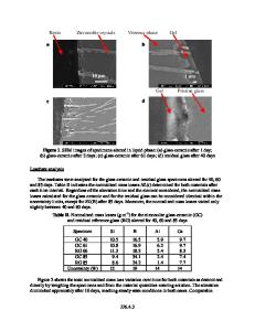
Abstract The aim of this research is discrimination of the hydrothermal alterations related to copper mineralization in the Daralu deposit, which is located in the south of Kerman, SE Iran. The rocks of the surrounding area consist of Eocene volcanics and Oligocene–Miocene intrusive bodies. The main mineralization has occurred in a granodiorite porphyry intrusion and to some extent in the nearby volcanic and pyroclastic rocks. Some methods such as band ratio, principal component analysis (PCA), and supervised classification methods like spectral angle mapper (SAM), spectral feature fitting (SFF), and linear spectral unmixing (LSU) were carried out on Advanced Spaceborne Thermal Emission and Reflection Radiometer (ASTER) and Enhanced Thematic Mapper Plus (ETM+) satellite images in order to detect propylitic, phyllic, and argillic alterations. In addition, potassic alteration was studied by LSU using region of interest (ROI) method for resampling on the basis of the field studies. LSU procedure displayed the best matching with the reality in comparison with the field observations at the Daralu deposit. Two major fault systems with NW-SE and NE-SW trends were determined by remote sensing using linear enhance and sharpen filter by visible near-infrared (VNIR) in ASTER bands. Propylitic, argillic, and phyllic alterations show the same directions with the major faults of the area. Keywords SAM . SFF . LSU . ROI . Copper porphyry deposit * Mona Sojdehee [email protected]
1
Department of Geology, Science and Research Branch, Islamic Azad University, Tehran, Iran
2
Earth Sciences Faculty, Shahid Beheshti University, Tehran, Iran
Introduction The usage of remote sensing to separate mineralization and alteration zones has become the initial approach for mineral prospecting in recent years (Ferrari 1992; Kenea 1996, 1997; Yamaguchi et al. 1998; Crosta et al. 2003; Ramadan and Kontny 2004; Galvão et al. 2005; Ninomiya and Cudahy 2005; Al Rawashdeh et al. 2006; Mars and Rowan 2006; Moghtaderi et al. 2007; Gad and Kusky 2007; Elsayed Zeinelabdein and Albiely 2008; Dogan 2008, 2009; Madani 2009; Shalaby et al. 2010; Amer et al. 2010; Azizi et al. 2010; Dehnavi et al. 2010; Beiranvandpour and Hashim 2011, 2012a, b; Rajendran et al. 2012; Sadeghi et al. 2013; Salem et al. 2013; Ciampalini et al. 2013; Rahimzadegan et al. 2014). Recognition of distribution of ore deposits and their relation to special alterations, survey of mining waste extensions, and regional structure and trending of mineral deposits are among the benefits of remote sensing methods in mineral exploration. Additionally, expansion of hydrothermal fluids and their consequent alterations in copper porphyry deposits make the remote sensing methods an effective too
Data Loading...