Comparison of the 2010 Chile and 2011 Japan Tsunamis in the Far Field
- PDF / 4,259,744 Bytes
- 26 Pages / 547.087 x 737.008 pts Page_size
- 69 Downloads / 303 Views
Pure and Applied Geophysics
Comparison of the 2010 Chile and 2011 Japan Tsunamis in the Far Field JOSE C. BORRERO1,2 and S. DOUGAL GREER1 Abstract—In this study we analyze water level data from coastal tide gauges and deep-ocean tsunameters to explore the farfield characteristics of two major trans-Pacific tsunamis, the 2010 Chile and the 2011 Japan (Tohoku-oki) events. We focused our attention on data recorded in California (14 stations) and New Zealand (31 stations) as well as on tsunameters situated along the tsunami path and proximal to the study sites. Our analysis considers statistical analyses of the time series to determine arrival times of the tsunami as well as the timing of the largest waves and the highest absolute sea levels. Fourier and wavelet analysis were used to describe the spectral content of the tsunami signal. These characteristics were then compared between the two events to highlight similarities and differences between the signals as a function of the receiving environment and the tsunami source. This study provides a comprehensive analysis of far-field tsunami characteristics in the Pacific Ocean, which has not experienced a major tsunami in nearly 50 years. As such, it systematically describes the tsunami response characteristics of modern maritime infrastructure in New Zealand and California and will be of value for future tsunami hazard assessments in both countries. Key words: Tsunami, time-series analysis, tide gauge, long waves, spectral analysis, wavelet analysis, ports, harbor resonance, New Zealand, California.
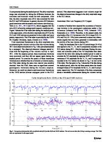
1. Introduction The tsunamis generated by the 2010 Chile and 2011 Tohoku earthquakes present a unique opportunity to examine the effects of major tsunamis in the far field. These tsunamis complement each other for a number of reasons. First, the events occurred just 1 year apart with source regions located on opposite corners
Electronic supplementary material The online version of this article (doi:10.1007/s00024-012-0559-4) contains supplementary material, which is available to authorized users. 1 eCoast Ltd., Box 151, Raglan 3225, New Zealand. E-mail: [email protected]; [email protected] 2 Department of Civil and Environmental Engineering, University of Southern California, Los Angeles, CA, USA. E-mail: [email protected]
(northwest and southeast) of the Pacific Basin, thus providing an interesting juxtaposition of the distributed effects (Fig. 1). Second, the tsunamis were recorded on a large number of coastal tide gauges and deep-ocean tsunameters. Of interest in this study are the recordings from the relatively dense arrays of tide gauges near New Zealand and California, located at the alternate opposite corners of the Pacific (northeast and southwest) relative to the source regions (northwest and southeast), as well as the recordings of the tsunami wave forms on the Pacific-wide array of Deep-ocean Assessment and Recording of Tsunamis (DART) tsunameters. Third, the Pacific Ocean has not experienced a significant transoceanic tsunami since the 1960 Chile and 1964 Al
Data Loading...