Integration of Remote Sensing & GIS to Manage the Sustainable Development in the Nile Valley Desert Fringes of Assiu
- PDF / 12,104,833 Bytes
- 16 Pages / 595.276 x 790.866 pts Page_size
- 75 Downloads / 261 Views
RESEARCH ARTICLE
Integration of Remote Sensing & GIS to Manage the Sustainable Development in the Nile Valley Desert Fringes of Assiut-Sohag Governorates, Upper Egypt Mostafa kamel 1 & El Sayed M. Abu El Ella 2
Received: 28 June 2015 / Accepted: 30 November 2015 # Indian Society of Remote Sensing 2016
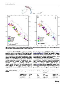
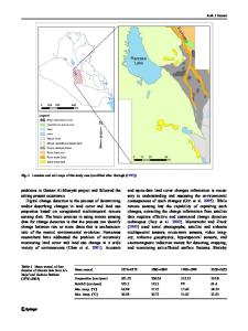
Abstract The growing population and the need for improving the living conditions of Egyptian community have resulted in the establishment of new urban areas, industrial zones, land reclamation, and different types of developmental projects. In the Nile Valley, the only available areas for carrying out such activities are the desert fringes surrounding the floodplain on both sides of the Nile Valley. This study examines the use of image processing mapping to landuse and land cover changes for the desert fringes along the Nile Valley between Assiut-Sohag area between 1984 and 2013 (satellite images). The layers of landuse map were digitized by heads-up digitization method in GIS environment. Similarly the layers of landuse map (2013) were generated by supervised classification of satellite imagery. The training site was created by referring landsat7 ETM+ and Landsat 8 satellite imagery with help of GPS (Global Positioning System) coordinates in GIS environment. Supervised classification technique was adopted to classify the satellite image in GIS (Geographic Information System) software environment. The classified image was converted into vector format and estimated the total area of each class by using geometry tools of GIS software. The landuse changes between 1984, 2000 and 2013 were compared and displayed in geographical or map format in 1:100000 scale. Also, this paper describes a study that was carried out to perform supervised and unsupervised techniques on remote sensing data for land cover classification and to evaluate the accuracy result of both
* Mostafa kamel [email protected]
1
Geology Department, Faculty of Science, Al Azhar University, Assiut Branch, Egypt
2
Geology Department, Faculty of Sciences, Assiut University, Assiut 71516, Egypt
classification techniques. The land cover classes for the study area were classified into 5 themes. Ground verification was carried out to check and assess the accuracy of classification based on Google Earth pro. A total of 72 sample points were collected using Systematic Random Sampling. The results showed that the overall accuracy for the supervised classification was 95.8 % where Kappa statistics was 0.78. Keywords Satellite image . Landuse . Supervised and unsupervised classifications . Accuracy assessment . RS & GIS . Nile valley
Introduction During the past few decades, with increasing of the population and developing the technologies, people have emerged as the most powerful and universal instrument of environmental change in the biosphere. Both globally and locally the land cover today is altered primarily by direct human use. Viewing the Earth from space has become essential to comprehend the cumulative influence of human activities and its natural
Data Loading...