Salinity mapping model and brine chemistry of Mishrif reservoir in Basrah oilfields, Southern Iraq
- PDF / 3,438,750 Bytes
- 12 Pages / 595.276 x 790.866 pts Page_size
- 12 Downloads / 287 Views
ORIGINAL PAPER
Salinity mapping model and brine chemistry of Mishrif reservoir in Basrah oilfields, Southern Iraq Salih Muhammad Awadh 1 & Heba S. Al-Mimar 1 & Abdullah A. Al-Yaseri 2 Received: 18 May 2018 / Accepted: 7 September 2018 # Saudi Society for Geosciences 2018
Abstract Cation and anion concentrations and boron isotopic ratio of brines in the Mishrif Formation (U. Campanian-Tuoronian) from North Rumaila, South Rumaila, Majnoon, Zubair, and West Qurna oilfields southern Iraq were investigated. The aims of this study are to define the type, origin of the oilfield waters, and its flow model in the subsurface oil traps. Mishrif brines are characterized by having higher concentrations of sodium (50,500–84,200 ppm), chlorine (102,100–161,500 ppm), and boron (21.9–31.1 ppm) with lower sulfate contents (187–1350 ppm) relative to the modern seawater. Samples have slightly depleted in δ 11B (35.4‰) relative to seawater fall near the seawater intrusion of the diagram Cl/Br Vs δ 11B and occupied the field of evaporated seawater on the diagrams of Cl vs B and 1/Br vs δ 11B. The brine of Na-chloride type is characteristics of the Mishrif reservoir in all oilfields except WQ which defined by facies of Na-Ca-chloride type. A weak acidic brine of a salinity six-time greater than seawater plays a role in generating the formation pressure and controlling the fluid flow. The reservoir rock-fluid interactions were interpreted using boron isotopes which eventually reveal an ongoing dilution process by the present seawater intrusion and injection water used for the secondary production under conditions of high-temperature digenetic reactions. The 11 B in the oilfield water is resulted from uptake of the tetrahedral borate after precipitation of calcium carbonate, while 10B is sourced from the thermal maturation of organic matters. Keywords Potential mapping . Salinity . Boron isotopes . Mishrif reservoir . Oilfield water
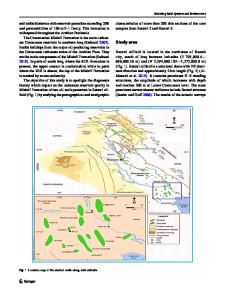
Introduction The Mishrif brines were studied in North Rumaila (RU), South Rumaila (R), West Qurna (WQ), Zubair (ZB), and Majnoon (MJ) oilfields located in southern Iraq (Fig. 1). The chemistry of the oilfield waters is affected by the reservoir lithology, geological formations, through which the water passes, meteoric water, and the hydrocarbons (Awadh 2018). Mishrif Formation, a latest Cenomanian-Early
* Salih Muhammad Awadh [email protected] Heba S. Al-Mimar [email protected] Abdullah A. Al-Yaseri [email protected] 1
Department of Geology, College of Science, University of Baghdad, POB 47182, Baghdad, Iraq
2
South Oil Company, Basrah, Iraq
Turonian age is a regional shallow water limestone succession that shoals upward, due to the pro-gradation from basinal deposits (Buchette 1993). It overlies oligosteginal carbonates of the Rumaila Formation near the Iraq-Iran borders and Basra area in southeastern Iraq (Owen and Nasr 1958; Dunnington et al. 1959; Alkersan 1975; Aqrawi et al. 1998). The Mishrif carbonate facies is recognized by four facies: restricted shelf, rudist build-up, open shelf, a
Data Loading...