Analysis of Urban Expansion and its Impacts on Land Surface Temperature and Vegetation Using RS and GIS, A Case Study in
- PDF / 2,571,412 Bytes
- 15 Pages / 595.276 x 790.866 pts Page_size
- 37 Downloads / 304 Views
ORIGINAL ARTICLE
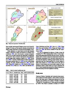
Analysis of Urban Expansion and its Impacts on Land Surface Temperature and Vegetation Using RS and GIS, A Case Study in Xi’an City, China Mohib Ullah1 · Jing Li1 · Bilal Wadood2,3 Received: 3 December 2019 / Accepted: 26 June 2020 © King Abdulaziz University and Springer Nature Switzerland AG 2020
Abstract The present study aims to explain the impacts of urban expansion on land surface temperature and vegetation of Xi’an City, China using integrated techniques of remote sensing (RS) and geographic information system (GIS). Urbanization is one of the potential driving factors for land use/land cover (LULC) change, vegetation decrease, and land surface temperature (LST) increase. To access information about the spatial and temporal land cover change, the use of two essential sources RS and GIS is indispensable. This study focuses on LULC changes in six districts of Xi’an City, China for the last three decades (1987–2018) using Landsat satellite images. The images from Thematic Mapper (TM), Enhanced Thematic Mapper (ETM+), and Operational Land Imager (OLI) of Landsat satellite are utilized. The results are as follows: (1) Xi’an experienced strong urbanization over the last 30 years with an increase of 69.6% in the urban area. The urban expansion pattern from 1987 to 2002 is alternate infilling and edge expansion in central districts, while from 2002 to 2018 is dominantly edge expansion toward outer districts. (2) Urbanization has negative effects on normalized difference vegetation index (NDVI); from 2002 to 2018 vegetation cover has decreased sharply in outer districts of Xi’an. (3) There is a synergetic relationship between urban expansion and LST. (4) The correlation between LST and NDVI is strongly negative, which indicates vegetation can relieve the effects of LST to some extent. Keywords Urbanization · Landsat satellite · Remote sensing · Spatial resolution · Xi’an · China
1 Introduction Urban land cover is relatively a small fraction of the total earth’s surface and expands on average twice as fast as their populations (Seto et al. 2012). According to DESA (2018), 55% of the total world’s population lives in urban areas, however, the proportion may increase to 68% by 2050. Projections show that population shift from rural to urban areas, combined with the overall growth of the world’s population * Mohib Ullah [email protected] 1
School of Geography and Tourism, Shaanxi Normal University, Xi’an 710119, Shaanxi, China
2
State Key Laboratory of Continental Dynamics, Department of Geology, Northwest University, Xi’an 710069, Shaanxi, China
3
Department of Geology, University of Swabi, Anbar‑Swabi 23561, KPK, Pakistan
could add another 2.5 billion people to urban areas by 2050, whereby about 90% of this growth may occur in Asia and Africa (DESA 2018). In China, the estimated urban population will reach one billion by 2050 (Gui et al. 2019). Since most of the socio-economic and cultural activities take place in cities (Fatemi and Narangifard 2019; Zhang et al. 2018; Ja
Data Loading...