Assessing the impacts of land-use/land-cover change on the development of urban heat island effects
- PDF / 4,092,594 Bytes
- 11 Pages / 439.37 x 666.142 pts Page_size
- 60 Downloads / 332 Views
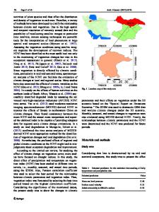
Assessing the impacts of land‑use/land‑cover change on the development of urban heat island effects Murat Atasoy1 Received: 20 May 2019 / Accepted: 23 November 2019 © Springer Nature B.V. 2019
Abstract Urban heat island (UHI) has been a detrimental problem over the last decades. Also, climate change has obtained more attention due to increased urbanization. Turkey is one of the countries experiencing a rapid urbanization which has resulted in significant UHI impacts on the regional climate and environment. This study was conducted in Osmaniye city, Turkey, where there is a need to determine the effects of land-use/land-cover changes (LUCC) on the UHI using Landsat images. The geospatial analyses were undertaken using USGS/NASA Enhanced Thematic Mapper Plus geospatial data from 2000 to 2018. The results showed that percent cover of urban areas significantly increased from 6.13 to 17.76%, broad-leaved forest cover decreased from 14.2 to 11.6%, road and rail network cover increased from 5.23 to 10.85%, and coniferous forest cover decreased from 15.85 to 9.02% between 2000 and 2018. During the process of urbanization from 2000 to 2018, most of the bare land cover was converted to agricultural lands and urbanized areas due to vegetative degradation, and industrial units cover increased from 7.76 to 9.53%. The land surface temperature was 35.57 °C for approximately 25% of the study area in 2000, while the same temperature was calculated for 76% of the study area in 2018. The results suggest that LUCC from vegetation to urbanized areas has significantly increased the land surface temperature. This implies that the application of remote sensing technique could help to design methods to mitigate UHI effects by estimating future land-use/land-cover change in urban areas. Keywords Land surface temperature · Land-use/land-cover change · Remote sensing · Urban heat island · Urbanization in Turkey
1 Introduction The estimates by the United Nations show that 60% of the world will be affected by urbanization by 2030 (Chun and Guldmann 2014). In recent years, one of the fundamental reasons of the climate change is the decrease in natural cover and substantial growth * Murat Atasoy [email protected] 1
Faculty of Architecture, Design, and Fine Arts, Osmaniye Korkut Ata University, 80000 Osmaniye, Turkey
13
Vol.:(0123456789)
M. Atasoy
of urbanization (Hosseini et al. 2015). Urban Heat Island (UHI) phenomenon is one of the most significant factors associated with this rapid urban growth around cities (Mirzaei 2015; Bokaie et al. 2016). The UHI was first apprised by Howard (1833), and the subject has gained momentum in the following years (Laosuwan and Sangpradit 2012). An UHI is a landscape that has specific warmth of the surface in comparison with its surroundings (Agbor and Makinde 2018). The fundamental driving factors of UHIs are alterations in land surface structure, energy utilization, and increase in impervious surfaces such as constructions, buildings, and concrete pavements leading to heat accumulation
Data Loading...