Drainage Problems in Areas Subject to Subsidence due to Oil Production
Oil extraction along the entire Eastern edge of the Lake of Maracaibo in Venezuela began in 1927. As a result, some 500 Km2 of continental land is now subject to settling or subsidence. A part of the affected area is lower than the water level of the lake
- PDF / 1,372,465 Bytes
- 10 Pages / 430.866 x 649.134 pts Page_size
- 36 Downloads / 296 Views
Drainage Problems in Areas Subject to Subsidence due to Oil Production A.lrazabal Obhidra Consult, C.A. j. Abf-Saab Maraven, S.A., Venezuela J. Murria,j. Groot Nedeco, The Netherlands SU~1MARY
Oil extracti on along the enti re Eastern edge of the Lake of Maracaibo in Venezuela began in 1927. As a result, some 500 Km 2 of continental land is now subject to settling or subsidence. A part of the affected area is lower than the water level of the lake (M.L.L.L.) and has to be protected by coastal dikes along a total length of 43 kilometers. At the present time, the lowest point is 5.5 meters below the level of the Lake, and the subsidence comes to 20 cm. per year in some places. In this area, one the most important and oldest oil-producing regions of the country, there is a capital intensive oil-industry network, as well as activity related in some way with that industry. Some 150.000 people live in the area. It is drained partly by gravity, in a natural manner through the rivers which cross it and with the use of canals to intercept the surface runoff and discharge it into the Lake. Additional drainage is provided by pumjing (25 stations with a total installed capacity of 270,000 m /hour) in the protected zones. In recognition of the drainage problem affecting the area and of its qynamic character, as a result of the subsidence, MARAVEN S.A., the largest oil producing company inland, contracted with the OBHIDRA CONSULT C.A for the preparation of a Drainage Master Plan under the coordination of MARAVEN S.A. and the technical advice of NEDECO. This plan calls for a 50-years planning scenario, with an intermediate scenari 0 of 25 years. MARAVEN S.A. has suppl ied projections of ground subsidence derived from the application of a mathematical model. With these projections, topographical maps were produced showing how the relief changes over time. K. V. H. Smith et al. (eds.), Hydraulic Design in Water Resources Engineering: Land Drainage © Springer-Verlag Berlin Heidelberg 1986
546
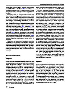
SITE OF THE AREA The area under consideration is located along the East coast of the Lake of Maracaibo (Bolivar Coast). The area under oil-drilling operations occupies 680 Km 2• Figure I Shows the geographic location of the Bolivar Coast.
11 0 jH-------tt------+-----~+~'+---__1
90~-----L---~--~-----~-
_ _ __~
PHYSICAL CONTEXT General Characteristics Geomorpho logy From the geomorpho 1ogi ca 1 poi nt of vi ew, the zone 1S made up of f1uvio-lacustrine plains characterized by savanndS with gentl e slopes (8 to 1 m/Km), extendi ng from the foothills of the Ziruma Mountain Range to the Coast. A part of the zone represents the deltas of the Tamare, Pueblo Viejo, Machango, and Misoa rivers. Hydrology The area is characteri zed by a rai ny season runni ng from May to November. Annual precipitation varies from 750 mm in the northern part of the zone to 1000 II1l1 in the south. Rainstorms tend to be short (less than 6 hours) and very intense; 75% of the rain falls in the first hour (100 lI1l1/hour for a rain with a 10-year return period). The ana
Data Loading...