GIS-based gully erosion susceptibility modeling, adapting bivariate statistical method and AHP approach in Gombe town an
- PDF / 5,338,460 Bytes
- 16 Pages / 595.276 x 790.866 pts Page_size
- 113 Downloads / 413 Views
Geoenvironmental Disasters
RESEARCH
Open Access
GIS-based gully erosion susceptibility modeling, adapting bivariate statistical method and AHP approach in Gombe town and environs Northeast Nigeria Ogbonnaya Igwe, Ugwuoke Ikechukwu John* , Onwuka Solomon and Ozioko Obinna
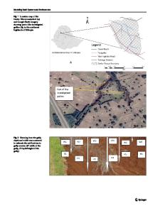
Abstract Gully erosion is a major environmental problem in Gombe town, a large area of land is becoming unsuitable for human settlement, hence the need for a gully erosion susceptibility map of the study area. To generate a gully inventory map, a detailed field exercise was carried out, during this investigation one hundred gullies were identified and studied extensively within the study area of about 550 km2. In addition to the mapped gullies, Google EarthPro with high-resolution imagery was used to locate the spatial extents of fifty (50) more gullies. Ten gully erosion predisposing factors were carefully selected considering the information obtained from literature, and multiple field survey of the study area, the factors include elevation, slope angle, curvature, aspect, topographic wetness index (TWI), soil texture, geology, drainage buffer, road buffer and landuse. In this study, a GIS-based Frequency Ratio (FR) and Analytical Hierarchy Process (AHP) models were employed to predict areas prone to gully erosion in Gombe town and environs. The result obtained from FR shows that drainage, soil texture, and slope have the highest correlation with gully occurrence, while the AHP model revealed that drainage buffer, soil texture, geology have a high correlation with the formation of a gully. Gully erosion susceptibility maps (GESM) were produced and reclassified into very high, high, moderate, and low zones. The overall accuracies of both models were tested utilizing area under the curve (AUC) values and gully density distribution.FR and AHP model have AUC values of 0.73 and 0.72 respectively, the outcome indicates that both models have high prediction accuracy. The gully erosion density distribution values revealed that gullies are concentrated in the very high susceptibility class and it decreases towards the low class, therefore the GESM produced using these models in this study area is reliable and can be used for land management and future planning. Keywords: GESM, GIS, Prediction, Frequency ratio, Analytical hierarchy process
Introduction One of the factors that endanger water and soil is soil erosion (Magliulo 2012). The major cause of land degradation around the world is soil erosion by gully erosion (Nampak et al. 2018; Rizeei et al. 2016). Gully erosion is defined as a deep channel that is formed by concentrated water flow, which in the process removes surface soils and materials (Kirkby and Bracken 2009). * Correspondence: [email protected] Department of Geology, University of Nigeria, Nsukka, Nigeria
The changes in the quantity of moisture content resulting from dry and wet seasons are a major factor contributing to cracks and grooves in clay formations consequently forming rilled erosion and gullies (Torri et al. 2012). Runoff ac
Data Loading...