Mapping and modeling mangrove biophysical and biochemical parameters using Sentinel-2A satellite data in Bhitarkanika Na
- PDF / 2,925,623 Bytes
- 12 Pages / 595.276 x 790.866 pts Page_size
- 71 Downloads / 323 Views
ORIGINAL ARTICLE
Mapping and modeling mangrove biophysical and biochemical parameters using Sentinel‑2A satellite data in Bhitarkanika National Park, Odisha Bikash Ranjan Parida1 · Anshu Kumari1 Received: 14 August 2020 / Accepted: 8 October 2020 © Springer Nature Switzerland AG 2020
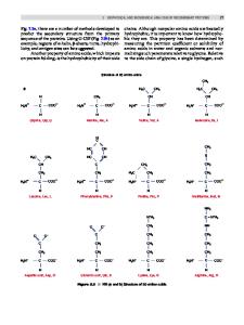
Abstract Mangroves are Earth’s most active and diversified saline wetlands, which play an essential role in protecting coastal communities from storm surge, cyclonic winds, tsunami, and tidal waves. Space-borne satellite data provide vital information for monitoring mangrove and retrieving health-related parameters. The objective of this study is to map and model biophysical and biochemical parameters of mangrove forests over the Bhitarkanika reserve forest located on the eastern coast of Odisha. The present study has employed Sentinel–2A sensor’s red-edge bands to derive both the aforementioned parameters. Furthermore, the near-proximal sensor (NPS) data were integrated with satellite data for mapping leaf chlorophyll and nitrogen contents with the help of an empirical model. The key findings indicate that EVI (Enhanced Vegetation Index) and measured leaf chlorophyll were significantly and positively correlated (R2 = 0.78). EVI showed a stronger relationship with foliage pigments, such as leaf chlorophyll and nitrogen. Leaf area index (LAI) of mangrove ranged between 1 and 4, with healthy dense mangrove depicted LAI more than 2.5. Leaf chlorophyll content for dense mangrove forests showed between 40 and 90 μg/ cm2 as estimated from satellite-based (i.e. NAOC index) and empirical model. However, the NAOC (Normalized Area Over reflectance Curve) index has relatively overestimated the chlorophyll. A similar pattern was also obtained for leaf nitrogen. Nevertheless, integrating both satellite and handheld NPS instruments has provided a robust and dynamic way to monitor mangrove forests’ health conditions. Satellite-derived biophysical and biochemical parameters offer vital information on mangrove, which could be crucial towards conservation, plantation, and mangrove management. Keywords LAI · EVI · Chlorophyll · Nitrogen · Empirical model · NAOC
Introduction Mangrove is known for the intertidal ecosystems that live in coastal environments comprising estuaries, lagoons, creeks, and intertidal mudflats. Mangrove forests are typically seen in coastal saline or brackish water, which has tangled roots located above ground. Mangroves play a vital role in conserving coastal ecosystems and livelihood for coastal populations (Fei et al. 2011). The mangrove forests balance the shorelines and reduce the destructive impact of natural disasters, such as tsunamis, cyclones, storm surge, and coastal * Bikash Ranjan Parida [email protected] 1
Department of Geoinformatics, School of Natural Resource Management, Central University of Jharkhand, Ranchi 835205, India
erosion processes, as it dissipates the wave energy (Awange and Kyalo Kiema 2013). Mangrove forests also directly contribute to coastal communities’ economy and livelihood by providi
Data Loading...