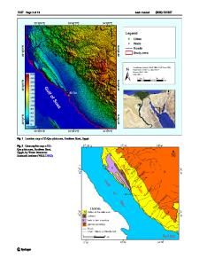
Use of the airborne magnetic data for edge basalt detection in Qaret Had El Bahr area, Northeastern Bahariya Oasis, Egyp
- PDF / 9,733,790 Bytes
- 17 Pages / 595.276 x 790.866 pts Page_size
- 10 Downloads / 212 Views
ORIGINAL PAPER
Use of the airborne magnetic data for edge basalt detection in Qaret Had El Bahr area, Northeastern Bahariya Oasis, Egypt Mahmoud Elhussein 1 & Mohamed Shokry 2 Received: 18 July 2019 / Accepted: 27 April 2020 # Springer-Verlag GmbH Germany, part of Springer Nature 2020
Abstract In this study, different interpretation techniques have been applied to the airborne magnetic data to detect the subsurface basaltic edges in Qaret Had El Bahr area, Northeastern Bahariya Oasis, Egypt. These techniques are as follows: the power spectrum, Source Parameter Imaging (SPI), tilt derivative or tilt angle, Euler deconvolution, and forward modeling. The depth to the basement calculated from the different techniques is mostly matched. Also, the lineaments have been analyzed by extracting these lineaments from the geological map, Reduction to the Pole (RTP) magnetic map, and regional and residual magnetic map. The rose diagrams of these lineaments have been established to define the main trends in the study area as well as the trend of the basalt, which is the main target in this study. Keywords RTP . SPI . Tilt angle . Depth estimation
Introduction Our area of interest (study area) (Fig. 1) lies in the Western Desert, to the Northeastern Bahariya Oasis, Egypt. It is bounded by latitudes 28°00′ and 29°15′ N and longitudes 29°00′ and 30°00′ E. The aeromagnetic survey is very useful in delineating or mapping subsurface magnetic sources (Elkhodary and Youssef 2013). Aeromagnetic measurements are routinely presented in form of maps constituting magnetic anomaly of interest that are produced from sources with different geometric, located at various depths (Salawu et al. 2019a; Salawu et al. 2019b). Aeromagnetic maps can be applied in many earth science studies such as geothermal, hydrological archeological, hydrocarbon, and mineral investigations (Reford and Sumner 1964; Mehanee and Zhdanov 2002; Zhdanov et al. 2004; Paoletti et al. 2013; Mehanee 2014; Pei et al. 2014; Eppelbaum 2015; Essa and Elhussein
* Mahmoud Elhussein [email protected] 1
Geophysics Department, Faculty of Science, Cairo University, P.O. 12613, Giza, Egypt
2
Nuclear Materials Authority, P.O. Box 530, Maadi, Cairo, Egypt
2016; Maineult 2016). Central to the analyses and interpretation of aeromagnetic maps is the estimation of magnetic basement depths (Deng et al. 2016; Salawu et al. 2019b), outlining the lateral changes in the magnetic susceptibilities (Oruç and Selim 2011), delineating the structural features (Al-Garni 2010; Gabtni et al. 2016), and recording the Curie depths (Aboud et al. 2011). This research is mainly committed to find and outline subsurface sources (basaltic sheet) and their extensions, considering the fact that the study area is along the TransAfrican basalt lineament and also situated between two of six exposed Egyptian Oligocene volcanic basalts. Analytical signal (total gradient), tilt angle, Source Parameter Imaging (SPI), and the 3D Euler deconvolution are standard tools used to map structural features and to es
Data Loading...