Assessment of surface water quality and its spatial variation. A case study of Ramganga River, Ganga Basin, India
- PDF / 3,718,363 Bytes
- 9 Pages / 595.276 x 790.866 pts Page_size
- 27 Downloads / 397 Views
ORIGINAL PAPER
Assessment of surface water quality and its spatial variation. A case study of Ramganga River, Ganga Basin, India Mohd Yawar Ali Khan 1 & Khalid Muzamil Gani 2 & Govind Joseph Chakrapani 1
Received: 14 January 2015 / Accepted: 18 September 2015 # Saudi Society for Geosciences 2015
Abstract Ramganga River is the main tributary of the Ganges River which is the most sacred and largest river basin of India. For effective management of Ganges, assessment of water quality in its tributaries is must, and this river lacks it so far. The present study focuses on the evaluation of water quality of this river and its adjoining tributaries. Organic pollution indicators, chemical oxygen demand (COD) and biological oxygen demand (BOD5) of river water ranges from 15.2 to 55.5 mg/L and 7.1 to 29 mg/L, respectively. Nutrient parameters nitrate (NO3−N) and phosphate (PO42−-P) of river water ranges from 0.2 to 12.7 mg/L and 0.02 to 0.76 mg/L, respectively. While in tributaries, these parameters range from 0.2 to 9.9 mg/L and 0.03 to 1.47 mg/L, respectively. The most polluted stretches of river were from Moradabad to Farrukhabad via Bareilly especially in terms of organic pollution. Pair sample t test applied to compare the water quality of river and its tributaries revealed no significant difference in COD, NO3−-N, PO42—P, and fluoride (F−) while sulfate (SO42−) was significantly large (25.1 mg/L)
* Mohd Yawar Ali Khan [email protected] Khalid Muzamil Gani [email protected]
Govind Joseph Chakrapani [email protected]
1
Department of Earth Sciences, Indian Institute of Technology Roorkee, Roorkee 247667, India
2
Department of Civil Engineering, Indian Institute of Technology Roorkee, Roorkee 247667, India
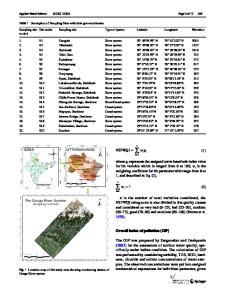
in tributaries. The spatial variation in water quality of river was addressed by cluster analysis (CA) which grouped the 16 sampling points into three significant clusters corresponding to lower pollution, moderate pollution, and severe pollution regions. The results from CA restructure the entire sampling campaign to a cheaper and less-effort sampling program that will be helpful in water quality assessment and management of the river. Keywords Cluster analysis . Ganges River . Physicochemical parameters . Ramganga River . Water quality
Introduction Surface water comprises of water that flows through the land in the form of creeks, springs, rivers, lakes and oceans (Manahan 1993). Nowadays, one of the most severe matters of concern is the quality of surface water, and the most susceptible water bodies to pollution are rivers because they carry a large amount of industrial and municipal wastewater along with fertilizers in the form of runoff from agricultural land. Natural processes like soil erosion, weathering processes, and the anthropogenic effects like municipal waste discharge, agricultural, and industrial activities play a major role in determining the quality of surface water in a region (Carpenter et al. 1998; Jarvie et al. 1998). Organic content of water is a contribution of crop wre
Data Loading...