Geomorphology and drainage network of Ras Banas Peninsula, Egyptian Red Sea coast: a model of coastal threshold
- PDF / 1,184,222 Bytes
- 10 Pages / 595.276 x 790.866 pts Page_size
- 8 Downloads / 345 Views
ORIGINAL PAPER
Geomorphology and drainage network of Ras Banas Peninsula, Egyptian Red Sea coast: a model of coastal threshold Kamal Abou Elmagd & Ashraf Emam
Received: 23 December 2011 / Accepted: 15 August 2012 # Saudi Society for Geosciences 2012
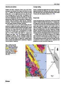
Abstract Ras Banas Peninsula is a large triangular tract of land jutting out into the Red Sea. It extends about 40 km eastward out of the general trend of the Red Sea coast of Egypt, covering an area of about 600 km2. Three sandy spits are jutting out from the main body of the peninsula into the Red Sea, possibly representing relics of structural trends, two of which are located at the western part and the third one is extending from the eastern edge forming a further seaward extension of the main body. A series of isometric and contour maps of the whole area under investigation are provided in digitized visual form of geomorphologic features, landforms and slope configuration. According to difference in relief, the study area can be subdivided into three topographic divisions, namely coastal plain (150 m). Drainage and lineament maps of the drainage networks were prepared from the topographic map and satellite images of the area. The prepared lineament map shows four main trends that control the configuration of the drainage system in the study area. These trends are Aqaba trend (NE–SW to NNE–SSW), Red Sea trend (NW–SE to NNW–SSE), Nubian trend (N–S), and Tethyan trend (E–W). It is clear that the structural trends, lithology and general slope are the main controls of developing parallel and dendritic drainage patterns in the area. Both geomorphology and drainage system
K. A. Elmagd : A. Emam (*) Geology Department, Faculty of Science, Aswan University, Aswan 81528, Egypt e-mail: [email protected] K. A. Elmagd e-mail: [email protected]
configuration have great influences on the land use and natural hazards affecting the peninsula especially torrential floods and sea level fluctuations. Keywords Drainage network . Geomorphology . Ras Banas . Slope . Land use . Torrential floods
Introduction Ras Banas Peninsula is a part of Egyptian Red Sea coast, between latitudes 23°52′00″N and 24°10′00″N and longitudes 35°25′00″E and 35°47′00″E. Few detailed geologic studies were carried out on the peninsula (e.g. Felesteen et al. 1993; Abou Elmagd 1995). However, several studies on the geology, relative sea level changes, geomorphology, land use and natural hazard assessment were published on other vicinity areas along the Red Sea coast north of Ras Banas (e.g. El-Akkad and Dardir 1966; Khedr 1984; El Rakaiby 1989; El Shamy 1992; Fouda and Gerges 1994; Yehia et al. 1999; Ashmawy 2001; Nasr et al. 2003; Sultan and Milewski 2008; Azab 2009; EI-Etr et al. 2009; Abou Elmagd et. al. 2010). Lithologically, Ras Banas Peninsula is dominated by a sedimentary sequence ranging in age from the Middle Miocene to the Holocene unconformably resting on elongated exposures of igneous and metamorphic rocks belonging to the Precambrian Basement Complex (Fig. 1). Stratigraphically, the s
Data Loading...