Orientation and Navigation Cues
For proper orientation and navigation, animals use a variety of reference cues. These cues may be of different types, such as visual objects, smells, or even the geomagnetic field, and may require different senses to perceive these navigational markers. T
- PDF / 1,011,697 Bytes
- 76 Pages / 595 x 842 pts (A4) Page_size
- 74 Downloads / 365 Views
Orientation and Navigation Cues
Abstract For proper orientation and navigation, animals use a variety of reference cues. These cues may be of different types, such as visual objects, smells, or even the geomagnetic field, and may require different senses to perceive these navigational markers. The importance or choice of a particular cue or cues may depend on the navigational task in question, starting from short-range navigation that may apply for an area of just a few meters to long-distance navigation during, say, bird migration. The conditions under which animals navigate are also diverse, so that a navigating subterranean mammal underground is expected to employ other senses than a bird looking for a hidden food cache, and birds migrating at night probably rely on a navigation strategy slightly different to that employed by those migrating during the daytime. This chapter describes what cues animals use for orientation and navigation, and what senses they employ in any particular case. Among the conventional senses described in any animal physiology book, the nature of the enigmatic hypothetical magnetic sense and its applications in animal navigation are discussed.
1.1 1.1.1
Magnetoreception Earth’s Magnetic Field
Earth’s magnetic field, also called the geomagnetic field, has been shown to constitute a significant orientation and navigation cue for many migrating animals. It is generated deep in the Earth’s core, and consists of two major components – dipole and non-dipole. The dipole component, as can be inferred from its name, creates two poles at the surface of the Earth that are geographically close to the rotational poles, also known as geographic poles of the planet, so that the vector of the field equal intensity lines at the South Pole (or the Antarctic Pole) is directed upwards, making the lines leave the surface of the Earth. Then the lines curve
A. Rozhok, Orientation and Navigation in Vertebrates, © Springer-Verlag Berlin Heidelberg 2008
1
2
1 Orientation and Navigation Cues
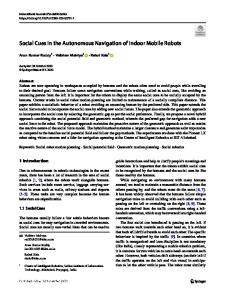
Fig. 1.1 Schematic view of the geomagnetic field. Dashed arrows indicate the geomagnetic field lines with different angles of inclination across the surface of the Earth. The inclination distribution of the western hemisphere (not shown) is symmetrical (adapted from Wiltschko and Wiltschko 1996)
around the planet and re-enter the ground at the Arctic Pole, being parallel to the Earth’s surface at the magnetic equator. So, at different latitudes, the magnetic vector is characterized by different inclination, or dip, of the magnetic lines as shown on Fig. 1.1. What is this vector? At the Earth’s surface, the geomagnetic field vector (usually denoted by F) can be decomposed into three constituent vectors. Taking the point of origin as the origin of a Cartesian coordinate system we can decompose F into the x-axis that coincides with the meridian towards the north, the y-axis directed along the geographic parallel towards the east, and the z-axis that is vertical at the point of origin and positive downwards. The three c
Data Loading...