Modeling predictive assessment of soil erosion related hazards at the Uva province in Sri Lanka
- PDF / 2,475,649 Bytes
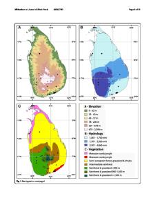
- 16 Pages / 595.276 x 790.866 pts Page_size
- 43 Downloads / 240 Views
ORIGINAL ARTICLE
Modeling predictive assessment of soil erosion related hazards at the Uva province in Sri Lanka I. D. U. H. Piyathilake1 · R. G. I. Sumudumali1 · E. P. N. Udayakumara2 · L. V. Ranaweera2 · J. M. C. K. Jayawardana2 · S. K. Gunatilake2 Received: 26 May 2020 / Accepted: 13 August 2020 © Springer Nature Switzerland AG 2020
Abstract At present, soil erosion is one of the most prominent environmental and socio-economic concerns in Sri Lanka and identification of soil erosion hazard zones is crucial for applying effective soil and water conservation measures. Thus, the study assessed the soil erosion and generated soil erosion hazard zonation map for the Uva province in Sri Lanka by means of the Integrated Valuation of Ecosystem Services and Tradeoffs (InVEST) Sediment Delivery Ratio (SDR) model, which was developed as part of the Natural Capital Project, a partnership between Stanford University-USA, the Nature Conservancy (TNC), and the World Wildlife Fund (WWF), working with many other institutions. The estimated mean soil erosion rate of Uva province was 25.6 t ha−1 year−1 and which is ~ 3 times greater than the soil loss tolerance in Sri Lanka. However, the soil erosion rates of the major basins in the province ranged between 0.9 and 117.8 t ha−1 year−1. Based on this study, province was classified into five soil erosion hazard classes viz. low (0–5 t ha−1 year−1), moderate (5–12 t ha−1 year−1), high (12–25 t ha−1 year−1), very high (25–60 t h a−1 year−1), and extremely high (60 60 t ha−1 year−1) while only 0.9% of the area falls into extremely high erosion potential category (> 60 t ha−1 year−1) in Monaragala district. Thus, the soil erosion potential values of the present study are substantiated by Senanayake et al. (2013). Sediment export and sediment retention maps As explained by Sharp et al. (2018), the sediment export map (Fig. 8a) represents the total amount of sediment exported from each pixel that reaches the streams and sediment retention map (Fig. 8b) represents areas that contribute more to retention concerning all land use land cover types that are converted to bare ground. According to the findings, the mean sediment export of Uva province is 5.17 t ha−1 year−1 and the mean sediment export of Badulla and Monaragala districts are 353.60 and 1.14 t ha−1 year−1 respectively. Furthermore, according to the results, the mean sediment retention of the whole Uva province is 191.39 t ha−1 year−1 whereas the sediment retention of Badulla and Monaragala districts are 900.55 and 81.80 t ha−1 year−1. The total sediment export and the total sediment retention values of major watersheds, districts, and the whole Uva province is shown in Table 4. According to the results, Loggal Oya and Walawe River watersheds show the highest and the lowest sediment export values (27.31 and 0.07 t
Fig. 8 a Map showing the sediment export values of Uva province, Sri Lanka. b Map showing the sediment retention values of Uva province, Sri Lanka
13
Modeling Earth Systems and Environment
ha−
Data Loading...