Oil seeps affinity and basin modeling used for hydrocarbon discoveries in the Kifle, Merjan, and Ekheither fields, West
- PDF / 19,135,512 Bytes
- 22 Pages / 595.276 x 790.866 pts Page_size
- 39 Downloads / 308 Views
ORIGINAL PAPER
Oil seeps affinity and basin modeling used for hydrocarbon discoveries in the Kifle, Merjan, and Ekheither fields, West Iraq Thamer K. Al-Ameri & Amer Jassim Al-Khafaji
Received: 26 July 2013 / Accepted: 24 October 2013 / Published online: 13 November 2013 # Saudi Society for Geosciences 2013
Abstract Calculated C28/C29 sterane ratio, δC13‰ isotopes and plots of tricyclic terpane (C22/C21, C24/C23, and C26/ C25 and hopane (C35S/C34S, C29/C30, and C31R/C30) of Najaf and Karbala Governorates oil seeps are used to assess the Jurassic Butmah, Sargelu, and Lower unit of Najmah formations in Kifle, West Kifle, Merjan, and Ekhaither fields western part of the Euphrates rivers. Plots of Roch-Eval pyrolysis analysis data of 334 source rock samples on van Krevlen, production index, and petroleum potential diagrams as well as 1D PetroMod software basin modeling of timing and extent of the hydrocarbon generation have confirmed the petroleum generation timing and their transformation ratios from these source rocks. The generated oil have possessed lateral migration along the upper unit of the Najmah Formation to the site of the Abo Jir major fault where it is changed to vertical migration along the fault that intersect with the ground surface. During the vertical migration path, impregnations of all the successive layers with heavy oil and asphalt have occurred. Main oil reservoirs of Cretaceous Nahr Umr and Harth formations and the Tertiary Dammam– Euphrates Formation were charged from this vertical migration path. The accumulated oils are of 15–38 API with 1.45– 5.9 sulfur content in the Hartha Formation reservoir and 20– 35 API with 0.9–3.7 sulfur content in the Nahr Umr Formation reservoir.
Keywords Oil seep . Biomarkers . Hydrocarbon generation . Reservoir risk assessment . Migration path . West–Middle Iraq T. K. Al-Ameri College of Science, University of Baghdad, Jadiriyah, Baghdad, Iraq e-mail: [email protected] A. J. Al-Khafaji (*) College of Science for women, Babylon University, Hillah, Iraq e-mail: [email protected]
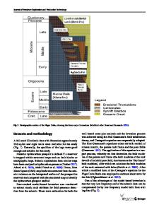
Introduction Oil seeps could flow on ground surface if part of it has not met any closure that could trap hydrocarbon accumulation through its migration pathway (Levorsen 1967; Selley 1998) such as ground intersection with carrier bed or fault. Biomarkers could be preserved in such oil seeps that have the ability to resist biodegradation and hence could form fingerprints that belong to the organic matter in the kerogen of the source rocks and the oil in reservoirs (Peters et al. 2005) Most of the petroleum in Iraq is sourced from cyclically bedded Jurassic shales and carbonates (Callovian–Oxfordian– Kimmeridgian ages) that accumulated in restricted intra-shelf Gotnia Basin including Mesopotamian Basin (Jassim and Goff 2006; Aqrawi et al. 2010). The Mesopotamian Basin formed on the passive margin platform of the Tethys Sea after Triassic rifting. It was separated from the other basins and from the open Tethys Sea to the east by shoals of calcarenite grainstones (Ayres et al. 1
Data Loading...