Shoreline change analysis along the coast between Kanyakumari and Tuticorin of India using remote sensing and GIS
- PDF / 1,856,005 Bytes
- 18 Pages / 595.276 x 790.866 pts Page_size
- 110 Downloads / 363 Views
ORIGINAL PAPER
Shoreline change analysis along the coast between Kanyakumari and Tuticorin of India using remote sensing and GIS P. Sheik Mujabar & N. Chandrasekar
Received: 21 February 2011 / Accepted: 24 August 2011 / Published online: 18 September 2011 # Saudi Society for Geosciences 2011
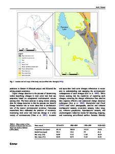
Abstract Shoreline is one of the rapidly changing landform in coastal area. So, accurate detection and frequent monitoring of shorelines are very essential to understand the coastal processes and dynamics of various coastal features. The present study is to investigate the shoreline changes along the coast between Kanyakumari and Tuticorin of south India, where hydrodynamic and morphologic changes occur continuously after the December 2004 tsunami. Multi-date satellite data of Indian Remote Sensing (IRS) satellites (1999, 2000, 2003, 2005, and 2006) are used to extract the shorelines. The satellite data is processed by using the ERDAS IMAGINE 9.1 software and analyzed by ArcGIS 9.2 workstation. The different shoreline change maps are developed and the changes are analyzed with the shoreline obtained from the Survey of India Toposheets (1969). The present study indicates that accretion was predominant along the study area during the period 1969–1999. But recently (from 1999 onwards), most of the coastal areas have experienced erosion. The study also indicates the reversal of shoreline modifications in some coastal zones. The coastal areas along the headlands have experienced both erosion and accretion. Though the coastal erosion is due to both natural and anthropogenic activities, the coastal zones where sand is mined have more impacts and relatively more rate of erosion than that of other zones. Improper and in-sustainable sand mining leads to severe erosion problem along this area. So the concept of sustainable P. S. Mujabar (*) National College of Engineering, Tirunelveli, India e-mail: [email protected] N. Chandrasekar Center for Geo-Technology, Manonmaniam Sundaranar University, Tirunelveli, Tamil Nadu, India
management should be interpreted in the management of the near-shore coastal sand mining industry. Keywords Coastal zone management . Erosion . Accretion . Hazards . Beach nourishment
Introduction Coastal areas are very important for human being since the beginning of time. Most of the big cities in the world are situated along the coastal area. About one third of the human populations are living in and around the coastal area. Due to abundant natural resources, the urbanization and population rapidly increases on the coastal area. Various developmental projects are made around the coastal areas. They put high pressure on it and lead to various coastal hazards like sea erosion, sea water intrusion, coral bleaching, shoreline change etc. The coastal landforms are highly dynamic in nature. They are continuously modified by natural and other man-made processes. Li et al. (2001) reported that the shoreline is one of the most unique features of earth surface. It is one of the twenty-seven features recognized by the
Data Loading...