Spatial analysis of groundwater potential using remote sensing and GIS in the Kanyakumari and Nambiyar basins, India
- PDF / 691,988 Bytes
- 12 Pages / 612 x 792 pts (letter) Page_size
- 48 Downloads / 312 Views
J. Indian Soc. Remote Sens. (December 2009) 37:681-692
RESEARCH ARTICLE
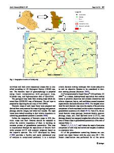
Spatial Analysis of Groundwater Potential using Remote Sensing and GIS in the Kanyakumari and Nambiyar Basins, India R.S. Suja Rose . N. Krishnan
Received: 19 December 2008 / Accepted: 19 August 2009
Keywords Ground water potential . Inter-correlation Matrix . Multi-criterion.
Abstract Remotely sensed data can provide useful information in understanding the distribution of groundwater, an important source of water supply throughout the world. In the present study, the modern geomatic technologies, namely remote sensing and GIS were used in the identification of groundwater potential zones in the Kanyakumari and Nambiyar basins of Tamil Nadu in India. The multivariate statistical technique was used to find out the relationship between rainfall and groundwater resource characteristics. It has been found out that groundwater not only depends upon rainfall, but various other factors also influence its occurrence. Eight such parameters were considered and multi criterion analysis has been carried out in order to find out the potential zones. Accordingly, it R.S. Suja Rose ( ) . N. Krishnan Department of Environmental Remote Sensing and Cartography, Madurai Kamaraj University Madurai – 625 021, India
email : [email protected]
had been concluded that the Kanyakumari river basin has more ground water potential, whereas the Nambiyar basin has less potential. Thus surface investigation of groundwater has proved to be easier, time consistent and cheaper using the geomatic technologies.
Introduction Groundwater is an important source of water supply throughout the world. The areas that are prone to excessive withdrawal, result in the shortage of groundwater, emphasize the need for the accurate estimates of the available subsurface resources and the importance of proper planning to ensure the continued availability of water. Although groundwater cannot be directly seen on the earth’s surface, a variety of techniques can provide information about its availability. Remote sensing from aircraft or satellite has recently become a valuable tool for understanding the sub-surface water conditions. The remotely sensed data of
682
J. Indian Soc. Remote Sens. (December 2009) 37:681-692
geomorphology, drainage, geological litho units and lineaments, soil, land use and the other related characteristics of an area can be spatially integrated by means of geographic information system and finally groundwater potential zones can be identified. In this field, attempts have been already made in different parts of the country by scholars like Obi Reddy et al. (1994), Krishnamurthy et al. (1992), Reddy et al. (1996), Rao et al. (1996), Goyal et al. (1999), Goyal et al. (2004), and Sikdar et al. (2004). Some other scholars like Vaidyanathan (1964), Das et al. (1997), Kumar and Tomas (1998), Tomas et al. (1999), Pratap et al. (2000) and Subba Rao et al. (2001) have arrived at the groundwater prospects by considering the geomorphological aspects that have been de
Data Loading...