Impact of densely distributed debris flow dams on river morphology of the Grand Canyon of the Nu River (upper Salween Ri
- PDF / 5,329,760 Bytes
- 13 Pages / 595.276 x 790.866 pts Page_size
- 38 Downloads / 306 Views
Liqun Lyu I Mengzhen Xu I Zhaoyin Wang I Lijian Qi I Xin Li
Impact of densely distributed debris flow dams on river morphology of the Grand Canyon of the Nu River (upper Salween River) at the east margin of the Tibetan Plateau
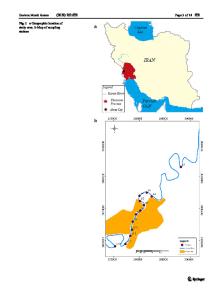
Abstract The Grand Canyon of the Nu River is the upper reach of the Salween River, and it is located on the eastern margin of the Tibetan Plateau. There were 187 debris flow gullies along the Grand Canyon of the Nu River, and debris flows from 53 of these gullies completely blocked the river. Debris flows have carried a large volume of sediment into the river since the Holocene and have formed high-density dams on the riverbed, with the maximum dam height exceeding 30 m. The Nu River comprises the repeated sections of straight flow connecting lakes and the debris flow dams that changed the movement and distribution of sediment in the river. In this paper, terrain data for debris flow dams were collected by Lidar, water depth data for the lakes were collected by an unmanned ship with a depth sounder, and the thicknesses of sediment deposits, both in the dams and in the lakes, were measured using a geophysical exploration method (EH4). The debris flow dams were stratified and had multi-stage stepped structures with high resistance because of repeated historical breaches of older dams and river coarsening, different from the structure of alluvial fans constructed by floods. The construction of debris flow dams and the sedimentation depths and volumes in the Grand Canyon were analyzed. The research shows that the high density of debris flow dams made the Grand Canyon stepped and the sedimentation rate greatly increased, reversing the Nu River Grand Canyon’s historical cutting trend. Keywords Nu River . Dammed lake . Debris flow fan . Alluvial fan . Steepness index Introduction The deeply incised valleys on the margin of the Tibetan Plateau are particularly prone to geohazards. Large landslides (volume > 106 m3) are easy to dam the deeply narrow valleys (Chen et al. 2013). The dammed lakes on the Tibetan Plateau are concentrated in the Jinsha Valley (upper Yangtze River), Yarlung Zangbo Valley (upper Brahmaputra River), Lancang Valley (upper Mekong River), and upper Indus River Valley (Lyu 2017). Research on most dammed lakes focuses on the stability of the dams and the flood risk due to dam breaks. The morphology of rivers discharging from lakes dammed by landslides presents a challenge when characterizing the filling behavior of dammed lakes and their possible subsequent drainage. Fluvial response to such a large supply of sediment from drainage of dammed lakes may theoretically involve adjustments to sediment yield and a river’s planform, cross-section, gradient, and bed configuration. Among the possible geomorphic response variables, a river’s longitudinal profile is assumed to have the longest adjustment time (Lyu 2017) and thus is an effective tool for tracking external disturbances in mountain rivers.
The study of landslide dams’ influence on river valley topography mainly focuses on lake
Data Loading...