Sediment Yield and Reservoir Siltation in Tigray
Sediment yield (SY) is the total mass of sediment that leaves a catchment per unit of time. It is the combined result of several erosion processes (e.g. sheet and rill erosion, gully erosion, riverbank erosion, landslides) and sediment deposition (e.g. at
- PDF / 743,256 Bytes
- 13 Pages / 419.527 x 595.276 pts Page_size
- 8 Downloads / 310 Views
23
Matthias Vanmaercke, Nigussie Haregeweyn, Amanuel Zenebe, Jan Nyssen and Jean Poesen
Sediment yield (SY) is the total mass of sediment that leaves a catchment per unit of time. It is the combined result of several erosion processes (e.g. sheet and rill erosion, gully erosion, riverbank erosion, landslides) and sediment deposition (e.g. at field boundaries, on footslopes, alluvial plains, river beds) taking place in the
M. Vanmaercke (&) Unit of Physical Geography and the Quaternary Period, University of Liége, Campus Sart-Tilman B11, 4000 Liége, Belgium e-mail: [email protected] N. Haregeweyn International Platform for Dryland Research and Education, University of Tottori, 680-001 Tottori, Japan e-mail: [email protected] A. Zenebe Institute of Climate and Society, Mekelle University, P.O. Box 231, Mekelle, Ethiopia e-mail: [email protected] J. Nyssen Department of Geography, Ghent University, Krijgslaan 281(S8), 9000 Ghent, Belgium e-mail: [email protected] J. Poesen Department of Earth and Environmental Sciences, KU Leuven, Celestijnenlaan 200E, 3001 Leuven, Belgium e-mail: [email protected] © Springer Nature Switzerland AG 2019 J. Nyssen et al. (eds.), Geo-trekking in Ethiopia’s Tropical Mountains, GeoGuide, https://doi.org/10.1007/978-3-030-04955-3_23
345
346
M. Vanmaercke et al.
river catchment. SY data from a catchment is typically recalculated to a unit area of 1 km2 and so represents the net erosion or denudation rate of a catchment, which is of large scientific interest. However, SY is also associated with a large number of challenges and issues. This is especially the case in Tigray, where observed SY values rank among the highest in Africa and even worldwide.
23.1
Sediment Yield in Tigray: Available Measurements and Estimates
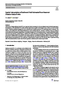
As in most African regions, only a limited number of SY measurements are available for Tigray. A review on SY data from Africa revealed that mean annual SY observations for 28 catchments are available in Tigray (ranging in size between 0.7 and 4600 km2; Fig. 23.1). Most of these SY measurements were conducted between 1995 and 2010 over relatively short measuring periods (1–10 years). Twelve of these observations were derived from measurements of river discharges (Q) multiplied by suspended sediment concentrations (SSC) recorded at gauging stations. These measurements not only provide estimates of the average SY, but also give valuable insights into the temporal dynamics of runoff and sediment transport. Nonetheless, several issues limit their accuracy. For example, reliable SY estimates typically require that Q and SSC are measured frequently during runoff events (in particular at moments when the river discharge is large). However, many of these events take place after sunset. Furthermore, much of these events are intense but short flash floods, which are difficult and sometimes even dangerous to measure (Photo 23.1). In several cases, installed equipment and measuring stages have been destroyed by floods. This, in combination
Data Loading...