A multistage hybrid model for landslide risk mapping: tested in and around Mussoorie in Uttarakhand state of India
- PDF / 24,556,258 Bytes
- 24 Pages / 595.276 x 790.866 pts Page_size
- 94 Downloads / 303 Views
ORIGINAL ARTICLE
A multistage hybrid model for landslide risk mapping: tested in and around Mussoorie in Uttarakhand state of India Mukunda Mishra1 · Tanmoy Sarkar2 Received: 8 December 2019 / Accepted: 9 September 2020 © Springer-Verlag GmbH Germany, part of Springer Nature 2020
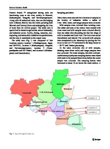
Abstract The study aims to develop a hybrid model approach for the assessment of the landslide (LS) risk qualitatively. It involves multiple consecutive stages of statistical prediction, machine learning, and mapping in the GIS environment. At the first stage, a landslide susceptibility map has been developed using the analytic hierarchy process (AHP) algorithm, coupled with the binary logistic regression (BLR) technique. The AHP model incorporates 11 geo-hydrological and environmental variables as predictors sourced from remote-sensing datasets to generate the LS susceptibility as output. Twenty-three fieldbased validation locations validate the test result. Pearson’s correlation coefficient (r) between the observed ( ŁCOMPUTED ) and predicted ( ŁPREDICTED ) values of LS susceptibility is 0.928 at 0.01 level of significance. At the next stage, the LS risk is evaluated considering the ‘risk trio,’ i.e., the combination of the hazard, exposure, and vulnerability. This stage involves the transformation of a range of qualitative datasets to the virtual workspace of machine learning. The landslide risk output has been predicted with an initial fuzzy model, incorporating a set of 32 rules for membership functions (MF). This initial model uses randomly selected 20% datasets to tailor the fuzzy rules through the adaptive neuro-fuzzy interface (ANFIS). The training to ANFIS results in framing 120 fuzzy rules for the best possible prediction of the outcome. The final LS risk map from the ANFIS output shows that more than 70% area is under high-to-very high LS risk. The model is tested in a 5′ × 5′ grid around the famous hill station Mussoorie in the state of Uttarakhand, India. The model exhibits a satisfactory level of accuracy for the present-study area, which has made us confident to recommend it. The multistage model is worthy of being applied for landslide risk mapping for the similar kinds of study areas, and also for other areas of landslide with necessary customization as deemed necessary. Keywords Susceptibility · Analytic hierarchy process · Fuzzy logic · Binary logistic regression · Multi-criteria · Hill slope · NDVI · Stream power index · Topographic wetness index
Introduction Landslides are considered as the most frequent and devastating hazard in the mountain environment and pose a real threat to human life, property, and resources (Kanungo et al. 2006; He et al. 2012). Ever-growing human intervention in the fragile geo-ecosystem in the hills of developing * Mukunda Mishra [email protected] Tanmoy Sarkar [email protected] 1
Department of Geography, Dr. Meghnad Saha College, Uttar Dinajpur, WB 733128, India
Department of Geography, Gazole Mahavidyalaya, Malda, WB, India
2
and underdeveloped countries in the for