A groundwater potential zone mapping approach for semi-arid environments using remote sensing (RS), geographic informati
- PDF / 9,727,702 Bytes
- 17 Pages / 595.276 x 790.866 pts Page_size
- 26 Downloads / 349 Views
ORIGINAL PAPER
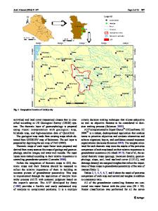
A groundwater potential zone mapping approach for semi-arid environments using remote sensing (RS), geographic information system (GIS), and analytical hierarchical process (AHP) techniques: a case study of Buffalo catchment, Eastern Cape, South Africa Solomon Temidayo Owolabi 1
&
Kakaba Madi 2 & Ahmed Mulakazi Kalumba 3 & Israel Ropo Orimoloye 3,4
Received: 12 May 2020 / Accepted: 26 October 2020 # The Author(s) 2020
Abstract Theme unsuitability is noted to have inhibited the accuracy of groundwater potential zones (GWPZs) mapping approach, especially in a semi-arid environment where surface water supply is inadequate. This work, therefore presents a geoscience approach for mapping high-precision GWPZs peculiar to the semi-arid area, using Buffalo catchment, Eastern Cape, South Africa, as a case study. Maps of surficial-lithology, lineament-density, drainage-density, rainfall-distribution, normalized-difference-vegetation-index, topographic-wetness-index, land use/land cover, and land-surface-temperature were produced. These were overlaid based on analytical hierarchical process weightage prioritization at a constituency ratio of 0.087. The model categorizes GWPZs into the good (187 km2), moderate (338 km2), fair (406 km2), poor (185 km2), and very poor (121 km2) zones. The model validation using borehole yield through on the coefficient of determination (R2 = 0.901) and correlation (R = 0.949) indicates a significant replication of ground situation (p value < 0.001). The analysis corroboration shows that the groundwater is mainly hosted by a fractured aquifer where the GWPZs is either good (9.3 l/s) or moderate (5.5 l/s). The overall result indicates that the model approach is reliable and can be adopted for a reliable characterization of GWPZs in any semi-arid/ arid environment. Keywords Groundwater exploration . Multi-criteria decision-making tool . Integrated geosciences . Topographic wetness index . Land surface temperature . Karoo
Introduction
Responsible Editor: Biswajeet Pradhan * Solomon Temidayo Owolabi [email protected] 1
Department of Geology, University of Fort Hare, Private Bag X1314, Alice, Eastern Cape 5700, South Africa
2
School of Biological and Environmental Sciences, Faculty of Agriculture and Natural Sciences, University of Mpumalanga, Private X11283, Nelspruit, Mpumalanga 1200, South Africa
3
Department of Geography and Environmental Science, University of Fort Hare, Private Bag X1314, Alice, Eastern Cape 5700, South Africa
4
Centre for Environmental Management, University of the Free State, Private Bag 339, Bloemfontein 9300, South Africa
The water shortage is a global issue, owing to the nexus of water-food-energy and its influence on livelihood and global economics. In South Africa, the water shortage may persist for a longer time due to the rate of increase in population, urbanization, and industries, as well as the regional severity of aridity on water resources, which is further complicated by climate change (Owolabi et al. 2020b). Ad hoc effort to
Data Loading...